Blog Image

Plods 2013

Plodding 2013

To record walks in 2013 by the WG plodders.

Walks done 2012, 2011, 2010, 2009. Walks History can be found here.

Use the Walkhighlands site to display GPX files.
Note upload .gpx files as .txt

Select the Schedule Category to view the Schedule. To see All Walks click "Plods 2013" above.

Steve M is going to be using these walks as training for a marathon 40 mile walk in July in aid of "Action Medical Research" and would be grateful for sponsorship and see the blog page

Charlwood

Surrey Posted on Fri, September 06, 2013 10:58:55

Walk #11

Date: Wed 11th September

Time: 5.30pm

Where: The Half Moon Charlwood

Parking: So far as I can remember it’s on-street parking outside the pub…

Designer: Andy S.

Route:

The walk will be in an anti-clockwise direction. Initially it follows the Sussex Border path and after 1 mile it turns south heading towards Ifield. The return route follows the western boundary of Gatwick airport with plenty of opportunity to spot planes!

GPX file (suffix changed to .txt):

Map:

Report:


Dormansland #2

Surrey Posted on Wed, August 14, 2013 21:33:33

Walk #10

Date: Wed 21st August

Time: 6.00pm

Where: The Plough Inn, Dormansland

Parking: There is limited parking at The Plough; best bet is in Ford Manor Road (the start of the walk)

Route:

A gentle stroll in the same area as walk #2. Route will be clockwise (but is possibly subject to change as I haven’t walked any paths in the area for a couple of months).

GPX file (suffix changed to .txt)

Map:

Report:

Due to a clash with a works social (is it really more important than a stroll through the countryside!?) we had somewhat reduced numbers this week. Those that did turn up enjoyed a very pleasant evening with glorious sunshine and temperatures in the low 20s. Not too many great views (sorry) nor too much in the way of hills so a wind-down towards the end of the waling season.


Reigate Hill

Surrey Posted on Thu, May 02, 2013 10:23:24

Walk #3

Date: 8th May

Time: 6.00pm

Where: Reigate Hill

Parking: National Trust car park at Margery Wood (£2.50 or free for members)

Designer: Andy S.

Route:

A figure of eight route crossing the motorway to Reigate Hill then back along the North Downs before returning through Walton Heath golf course and stopping off at The Sportsman (about 1km before the end of the walk).

GPX file (sufffix changed to .txt):

Map:

Report:

As per usual we picked one of the poorer evenings of the week weather-wise for the walk… however, it didn’t quite get bad enough to cause us to drag out waterproofs though it did make the views from the top of the downs a bit grey.

A good turn out again – 10 made the start of the walk and we picked up another 5 stragglers towards the end..

Andy changed the route slightly going round the smaller loop in the opposite direction – this meant we went down the steeper path and up the (very slightly) less steep one.

We started about 5 minutes late as we were waiting for some latecomers but then moved on briskly towards the top of Reigate Hill. We had a look round the fort before making our way down to the bottom of the hill – and almost immediately back up again. The walk along the top of the downs was probably in the worst of the weather which really closed down the view, unfortunately – you could just about make out Leith Hill but not much further.

Returning back across the golf course we picked up the rest of the crowd who’d sadly missed the start before stopping off at The Sportsman for well earned pint (at least for most of us).

Off the top of my head the plodders were: Andy S., Bertie, Phil C., Roy C., Ian C., Dan W., Mark, Pete F., Neal Z. and Franklyn. The late arrivers were Maud, Andre Latour (welcome to the plods Andre), Sonika, David J. and his better half.


Dormansland

Surrey Posted on Tue, April 16, 2013 21:32:44

Walk #2

Date: 24th April

Time: 6.00pm

Where: Dormansland

Parking: There is limited parking at The Plough; best bet is in Ford Manor Road (the start of the walk)

Route:

Lots of opportunities to bail out early if the weather turns bad smiley. The route was OK when I checked it a couple of weeks ago (except for one stretch which I’m now bypassing). Was a bit muddy on top last weekend but shouldn’t be too bad if the weather holds…
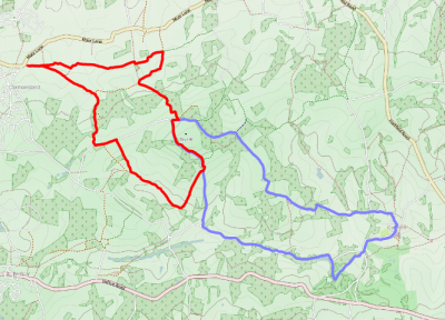
If anyone’s late the plan is to go clockwise round the route.

GPX file (suffix changed to .txt):

Map:

Report:

As usual we probably picked the worst evening of the week weather-wise for the walk – however, on this occasion, this meant only that it was a bit chilly and overcast. No rain and also dry underfoot.

This was probably a record turnout: a total of 20 people or thereabouts which even beats the Ditchling walk (see the picture at the top of the 2010 archive), so well done to all who turned out (particularly the newbies from the Fairwarp walk who didn’t allow the appalling weather then to put them off). A warm welcome to the new walkers and those returning from long layoffs.

The walk went as planned (despite the determined efforts of one or two to head in different directions) and a good pace was kept up by all with the group only really breaking up as we relaxed along the home stretch.

For the record I think the list of attendees was (in no particular order): Franklyn, Simon F., Sonika, Maud, Steve M., Andy S. & Bertie, Neal Z, Graham B., Roy, Phil C., Andy D., Pete F., Ian C., Lee, Hema, Gail, Marcela and Mark (apologies to anyone I’ve missed/mis-spelt). DT’s excuse of the week: painting the kitchen.

What we did (in red) and previous route in 2008 (Cowden).