Blog Image

Plods 2013

Plodding 2013

To record walks in 2013 by the WG plodders.

Walks done 2012, 2011, 2010, 2009. Walks History can be found here.

Use the Walkhighlands site to display GPX files.
Note upload .gpx files as .txt

Select the Schedule Category to view the Schedule. To see All Walks click "Plods 2013" above.

Steve M is going to be using these walks as training for a marathon 40 mile walk in July in aid of "Action Medical Research" and would be grateful for sponsorship and see the blog page

Nuthurst

Sussex Posted on Fri, July 26, 2013 16:38:12

Walk #9

Date: Wed 31st July

Time: 6.00pm

Where: The Black Horse Inn, Nuthurst

Parking:
Street parking by Nuthurst church and school, 200m south of the pub.
(The pub car park will not be available due to Quiz Night)

Designer: Ian C.

Route:
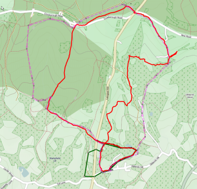
A circular walk of 6.7 miles (10.7km), going ANTI-clockwise.

GPX file (sufffix changed to .txt):

Map:

Report:

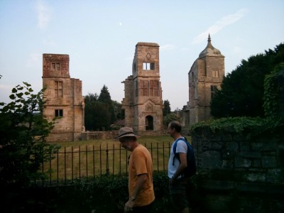
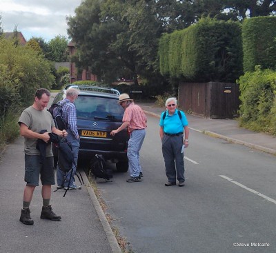
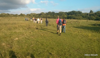
There was a good turnout for this walk, which mainly followed woodland tracks. The sighting of a deer near the end of the walk compensated to some extent for the lack of views and open vistas. Although the sky was overcast, there was no rain, and it was warm enough to sit in the pub garden and enjoy a well-earned drink at the end of the walk.


Forest Row

Sussex Posted on Wed, July 10, 2013 13:34:20

Walk #8

Date: Wed 17th July

Time: 6.00pm

Parking: Car Park Forest Row: Map

Pub: Black Peter Bar, Brambletye Hotel

Designer: Steve M.

Route:

The Route will leave Forest Row past the Golf Course and pass a memorial to troops stationed nearby for training during WW1. Then past the outlying Clump, Greenhall Toll. Crossing the A22 we will make our way to the first pub, The Goat, unfortunately it is no longer there! Then cross the Ashdown Forest pale and drop down towards Weir Wood reservoir. Before returning to Forest Row via Brambletye ruins. Distance 11lm depending of mood and navigation!

GPX:

Map:

Report:
After a false start in Forest Row to allow Dan to catch up we headed out past the Golf Course with a short pause at a WW1 memorial to troops training nearby. Once across the A22 a long climb took us to the summit of the walk. The next highlight was almost stepping on a young adder! Once out of Ashdown Forest we had a number of high stiles to negotiate which proved tricky for the dogs! A slight detour was taken to look at the ruins of Brambletye. Then onto The Brambletye Hotel for well earned refreshment.


Wivelsfield Green

Sussex Posted on Tue, July 02, 2013 09:54:43

Walk #7

Date: Wed 3rd July

Time: 6.00pm

Where: The Cock Inn, Wivelsfield Green

Parking: The Pub car park is limited; recommended parking is in Downsview Drive opposite

Designer: Ian C.

Route:

The route will be in a clockwise direction; late arrivers should easily be able to cut off sections in an attempt to catch up!

GPX:

PDF:

Report:

Despite DP having been on a jolly to Brighton and roadworks/holdups on the A23 we managed to leave before 6:15!

17 walkers & 3 dogs followed Ian’s route. DT found a lovely picture postcard cottage to admire, only spoilt by parked cars!

As usual entertainment was provided by Pete and his 2 black labradors as at each stile or gate as the dogs insisted on going different ways and enduring a great tangle of leads! The weather continued to improve and we even finished in sunshine despite Annies concern that Ian’s walk would take too long!

Total recorded distance of 12.3Km in 2hrs 48mins


Warnham

Sussex Posted on Fri, June 14, 2013 14:14:43

Walk #6

Date: Wed 19th June

Time: 6.00pm

Where: The Sussex Oak, Warnham

Parking: Car park beside the pub (there is also some on-road parking if required).

Designer: Neal Z.

Route:

Whilst the route looks like a figure-of-eight the plan is to walk both “loops” in a clockwise direction. Providing we don’t dawdle (and the weather is clement) there will be a short break for refreshment at the Chequers Inn in Rowhook.

GPX:

PDF:

Report from Mr Z.

All’s well that ends well they say. And it ended well. All 16 people, and two dogs, by my count, comfortably settled in the pub garden on the warmest day of the year. Not only that but Gail had brought cupcakes for us all!
Getting to that happy point, however, was the story of the day with 3 different groups of people having different stories. I knew I’d be in trouble when I accepted a lift from Mr Tilling…and sure enough we were in time to be late…(my suspicions were confirmed when his AC failed to work on the press of the button…shortly before hitting a closed M23…the cause of the 3 way split..and a stuffy spell for some).
Several others, already at the pub, were itching to start walking and only Fran was able to keep the group splitting into 4 mini groups. Once assembled, the larger group took in the deer park at the start and red phone box at the end with a quick half taken in half way round at Rowhook.
It was at Rowhook that we met up with Simon and Franklin…who took the shorter route there…they expressed disappointment at not meeting up with the third group who stayed around Warnham and occupied their time by checking out the graveyard in some detail. Such stories were swapped at the Sussex Oak over said cupcakes. The good news continued towards the end of the evening with Franklin getting a lift from Mr Tilling, who not only got him back safe and sound but also had worked some magic on the AC button.


Scayne’s Hill

Sussex Posted on Sat, June 01, 2013 20:09:41

Walk #5

Date: Wed 5 June 2013

Time: 18:00

Where: The Sloop Inn, Scayne’s Hill, Haywards Heath, RH17 7NP (map)

Parking: Use the car park alongside the pub

Designer: Pete F

Route: Strike off towards Scayne’s Hill which we skirt around. Head off towards Lindfield but again we do not go through it. Cross the track of the Bluebell railway and up through the horse fields at Tremaines. Go through the clay pits of Freshfield Lane brickworks before heading south to cross the Bluebell again, this time over a bridge. There are two alternative routes available from Freshfield Lane which would add half a mile or a mile to the planned route of 7.1 miles.

GPX:

PDF:

Report: We had another good turn out: 19 people plus 3 dogs. The weather avoided its current anti-summer bias. There were few bonus points to be had, no Roman roads, trig points or morris dance. We were able to sit outside the Sloop afterwards to sup our beer though the Harveys had run out since the weekend. Locally sourced scratchings were good.


Plumpton-Lewes

Sussex Posted on Fri, May 17, 2013 10:03:47

Walk #4

Date: 22nd May

Time: 6.00pm

Where: Plumpton Railway station

Directions: These were sent out in an email on the 16th. At some point you’ll need to catch the train to Plumpton (or get the train back there).

Designer: Mark

Route:

We start from Plumpton railway station and head east along the line before crossing it and heading south for the Downs. We climb to the top of the downs from just below Black Cap. After a brief walk along the top we descend to Offham cross the road and go down to the River Ouse. The last 3km is along the Ouse Valley walk and we finish by passing the Harvey’s Brewery and dropping in to the John Harvey Tavern.

GPX file (suffix changed to .txt):

Map:

Report:
A very good turnout with 16 walking from Plumpton to Lewes and 1 from Lewes to Plumpton! The weather had been well organised by Graham and we had a lovely sunny walk with great views back over the weald and down to the coast. AS always the John Harvey provided good refreshment! Distance recorded was 12.1km

More Photos from DTa added just to prove he was there!


Fairwarp

Sussex Posted on Thu, March 28, 2013 22:34:36

Walk

Date: 10th April 2013

Where: Fairwarp, Ashdown Forest

Parking: On road by Cricket ground

Designer: Steve

Pub: Foresters

Route

Modified slightly to be a bit more than 7Km
Weather looking cool and possibly damp with wind so dress accordingly. Going will be soft to wet so boots or waterproof shoes 😉

GPX file:

Map:

Report
A good turnout despite the poor weather. Rachel (Interica) was delayed but called Nick as we were walking away from Fairwarp. By a piece of poor navigation we came out to the road just as she was passing. This resulted a split of the group with Nick, Jim & Bev waiting while RAchel found some offroad parking. The main group by this time headed back towards the correct route via a number of valleys and a meandering route! By the time we got to Airman’s grave it was wet and getting dark.

We all met up at the pub afterwards. The longer route was logged at 8.8Km and the shorter estimated at 4.6km